
Earthquake modelling: Ground motion attenuation
- CATRisk Consultants

- 15 nov 2020
- 6 Min. de lectura
Ground motion attenuation
Ground motion attenuation is the regional decay of shaking between an earthquake’s epicentre of a building site.
The available geotechnical hazard data determines how the “regional ground shaking” will be modified by the local conditions at the site.
For a given event on a specific earthquake source, the model analyses the attenuation of seismic energy with distance to determine the level of ground shaking at a particular site.
The attenuation functions used for these calculations vary widely in different parts of the world because of differences in geologic & tectonic conditions that affect the transmission of seismic energy. E.g. earthquakes in the eastern half of continental U.S. are felt over much larger areas that events west of the Rocky Mountains in California.
This has been attributed to the older, thicker crust in the easter U.S., which transmits ground shaking more efficiently.


There are fewer significant events in the east of the United States from which to develop attenuation relationships resulting in greater variability in these areas.
Attenuation varies by region & by source type (strike slip/thrust and/or shallow/deep) considering weighted averages of published relationships.
For most analysis, there is no need to specify an attenuation function as these are assigned internally per source. It is a requirement only for “user defined EQ analysis”. North America earthquake model calculate ground shaking by either spectral acceleration (Sa), peak ground acceleration (PGA) or MMI Modified Mercalli Intensity.
1. Spectral acceleration (Sa)
It represents the maximum response of a structure shaking by the ground motion from an earthquake.
It is a good index of hazard to buildings, relates more to buildings than PGA motion. Sa are derived using the entire content of ground motion records & thus better represent the character of building response to shaking at a site, regardless of whether it is a rapid high intensity shock or a rolling long period motion.
For example, RMS Risklink software application calculates spectral acceleration as a function of source by magnitude and rupture process. And site by distance and soil type.
In the output file only spectral response or predominant period of the building is recorded e.g. 15 story building will experience different ground motion intensity for a given earthquake than a 5-story building at the same location.
Spectral acceleration is the major parameter used for North American regions for building & contents loss calculations. The only exception is for locations geocoded at county resolution, which use MMI.
1. Peak Ground Acceleration (PGA)
It is a subset of spectral acceleration, equivalent to 0-sec-period and it relates to building performance.
PGA is converted to MMI considering event magnitude, distance to fault line, soil type and earthquake type.
Attenuation for all North America region uses PGA. SA is primarily used for building & contents damage calculations.


Once ground shaking has been calculated, local geology for attenuation is then calculated. And landslide and liquefaction factors are taking into account in the calculations.
SOIL: soil value is actually an index related to shear wave velocity (Vs) at the top 30m at a site.
Shaking amplifications have lower Vs for soil and higher Vs for hard materials like rock.
In Mexico soil and liquefaction are derived from topographic data & validated against known map sources.
The slope at a site is converted to an estimated shear-wave velocity Vs using the premise that, steeper slopes typically can not support thick layers of unconsolidated materials. Those materials tend to collect in areas of lower slope over time.
Amplification: the actual degree of amplification is determined
1. by the input-ground motion
2. For calculation using ‘spectral response’ by the period structure.
SOIL vs. ROCK
Amplification of soil vs. rock is greater when the actual shaking intensity is low e.g. Northridge 6.0 earthquake in Santa Monica 1994 where there is a sedimentary basin of 21 km above rocks, Vs for soil is half of that of rocks.
At high shaking amplitudes such as those that occur near a fault, there is little difference between rock or soil grounds. Over 75% of North America is of rock geological material.

To other factors in the model can modify the ground shaking experienced by a building
1. Long period effects
2. Basin effects
SOILPERIOD (in the EQLOC table) reflect indexed rather than actual soil period values.
Surface materials are the largest contributors to site response e.g. a site location in deep sedimentary basin. Basins can amplify shaking, particularly at the longer periods that affect building. They are strongly influenced by 3D properties.
For example 2011 Christchurch earthquake in New Zealand where there is high liquefaction susceptibility.
The average s-wave velocity Vs = SQRT [(Elastic modulus or Young) / density] is 1357 m/s for dry rocks and between [1039-2401]m/s for wet rocks. Typically shear waves travel between [4-7] km/s with a mean velocity of 1585 m/s and standard deviation of 343 m/s, as liquids cannot be sheared secondary waves do not travel through liquids and only through the crust and mantle.
Primary wave velocity average is [7-12] km/s, mean velocity is 8 km/s
Liquefaction & landslide
Liquefaction and landslide are two forms of ground failure that can be triggered by strong shaking.
Liquefaction is the temporary transformation of a solid soil into a liquid state. Certain types of saturated, unconsolidated soils are subjected to repeated, cyclical vibration. Therefore, most commonly occurs during earthquakes.
Landslides are slope related failures of earth materials. The most common is saturation due to extended periods of rainfall.
The cyclical ground shaking imparted by earthquakes can act as a catalyst for slopes near to failure, however, this can generate additional potential for loss.
Both landslide and liquefaction add to damage for a site if they occur, independently of structure type.
This damage is conditioned on certain triggers to be met. These conditions involved both the shaking at the site and the magnitude of the event.
Because the duration for larger events is longer, the absolute acceleration value required is not as great.
If triggering conditions are met, additional damage is calculated based on shaking intensity and site susceptibility.
For underwriting, potential or opportunity is the probability that sufficiently strong ground motion will occur. Given strong ground motion occurs, susceptibility is the likelihood that landslide/liquefaction will occur.
Landslides require topographic contrast and are inversely correlated to liquefaction. Highest areas of liquefaction are flat lands.
It is possible to have a site with high susceptibilities to both if geocoding is at aggregate data level e.g. US County or provinces in most countries.
RMS Risklink for North America earthquake modelling provides both soil, liquefaction, and landslide data at different geocoding resolutions. In California state-wide high resolution or street address corresponds to a lookup on an actual geological map. Liquefaction for both San Francisco and LA.
For county level geocoded exposure liquefaction and landslide are not available but are considered in the aggregated loss.
For VRG geocoded liquefaction is calculated in California, Oregon, Washington, and New Madrid. North East, South East and Midwest.
AIR North America Earthquake Model
Attenuation
After the model generates the location, magnitude, and other fundamental characteristics of a simulated earthquake, it calculates intensity at each location affected by the event.
example of synthetic earthquake catalogue for western Canada


To do this the model uses attenuation relationships, which describes the rate at which the amplitude of the seismic waves decreases as the waves propagate outward from the source of the rapture.
This decrease is caused by the absorption and scattering of energy as the waves travel through the Earth.
Attenuation relationships, therefore, directly relate ground shaking intensity to earthquake magnitude and distance from earthquake rupture.
From a geological point of view there are two main zones:
1. Intra-plate zone of Central & Eastern United States.
2. Plate boundary zone of Western United States.

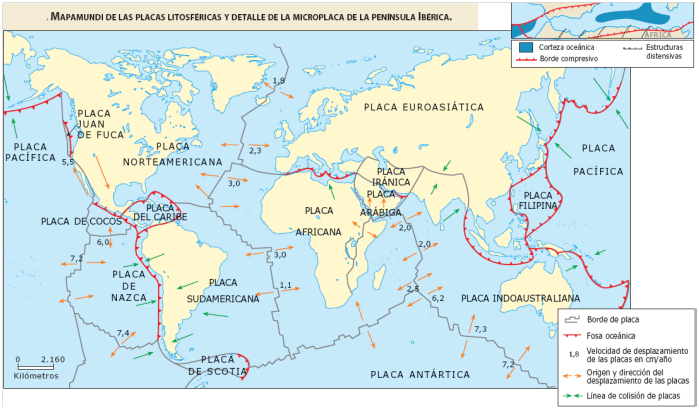
In California seismicity is primary controlled by inland boundary of the Pacific & North America plates. A complex web of faults, principal San Andreas fault which carries 70% of the right lateral strike-slip motion between plates.


In the Pacific North West is dominated by the subduction zone of Juan de Fuca plate beneath North America plate at the rate of 42 mm/year (4.2 cm/year). Tectonic stresses can produce earthquakes greater than M 8.0


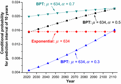
The recurrence rate, or return period, of the characteristic event is estimated using the relationship between the total seismic moment release rate & the characteristic magnitude. Brownian Passage Time is used for Pacific North West with recurrent intervals and mean passage time of 550 years.
For a characteristic event of magnitude, M the seismic moment is equal to:
Seismic moment = Mo = mu L W D = shear modulus x fault Length x fault Width x average displacement
Rate of seismic moment = M’o = shear modulus x fault Length x fault Width x slip rate
The recurrent rate for the characteristic event of magnitude M can be estimated as
1 / T = M’o / Mo
Where T is the recurrence interval of the characteristic magnitude.
Fuentes: RMS North American earthquake model and AIR North American earthquake model technical documents.


Comentarios